A new model for the western city district of Selinunte (Sicily)
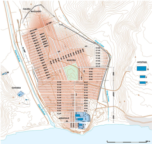
Fig. 1: Schematic city map of the Archaic-classical Selinunte from D. Mertens, Città e monumenti dei Greci d'occidente, Roma 2006, 174, Fig. 303.
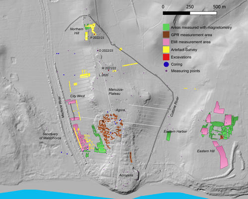
Fig. 2: Multidisciplinary research activities conducted during the first phase of the project, 2021-2024.
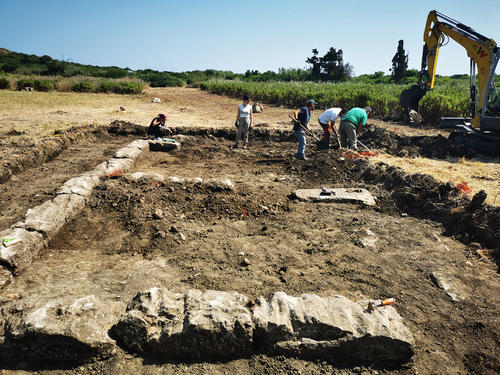
Fig. 3: Excavation of trench Q 2025, view from the north. The visible damage to the block’s surface is the result of decades of ploughing.
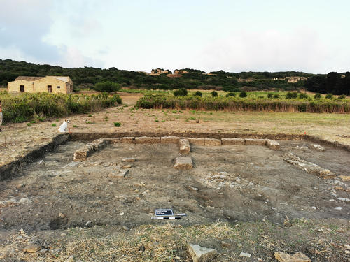
Fig. 4: View of trench Q 2025 from the west after the removal of the topsoil.
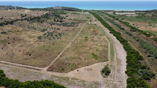
Fig. 5: Position of the three trenches Q 2025, S 2026 and T 2025 in the valley of the Modione River.
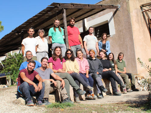
Fig. 6: Team of the 2025 excavation-campaign.
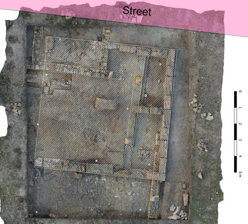
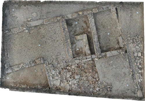
Fig. 7: Orthophoto showing the final stage of the excavation in October 2025. The hatched area shows the extension of the Hellenistic building.
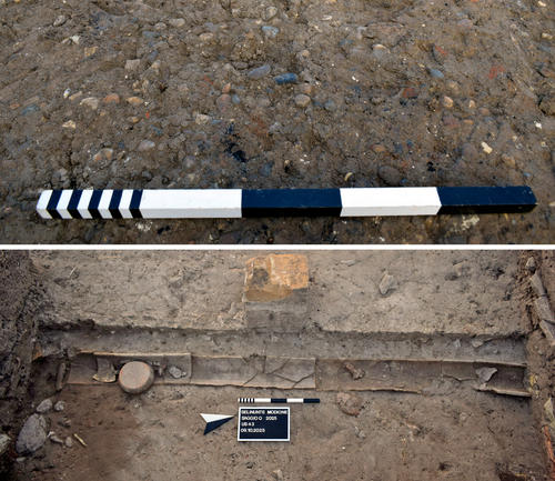
Fig. 8: Above: Close-up from the flooring of the courtyard. Below: Water channel in the eastern ambitus.
Fig. 9: Orthophoto of trench T 2025 at the end of the first excavation campaign.
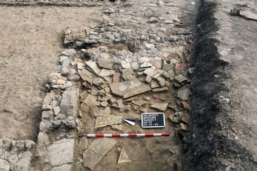
Fig. 10: View of collapsed roof of Room 4 with objects still in situ.
Summary
In 2021, the German Research Foundation approved funding for a multidisciplinary field project in the ancient Greek city of Selinunte in Sicily. Titled “A new model for the city of Selinunte”, the project aims to study and describe the overall structure of the westernmost Greek colony, including its formation and transformation processes. In a first phase of the project (2021-2024), this objective was pursued through a collaboration between the German Archaeological Institute in Rome and the Applied Geophysics Group of the Christian-Albrechts-Universität zu Kiel and with the cooperation of the Università degli Studi di Palermo and the Parco Archeologico di Selinunte, Cave di Cusa e Pantelleria.
The groundwork and starting point for the project is the well-known schematic map of the roughly 110 hectares large Archaic-Classical city (Fig. 1), obtained at the beginning of the century using a combination of archaeological and geophysical methods. The new engagement with the whole system of the city aims to complement and refine this map by allowing different chronological, functional and social realities to disrupt our vision of the ideal orthogonal Greek city. In recognition of the meticulous planning, surveying and division of the urban area at the end of the 7th century BC, the focus is now on the processes of development and transformation of the settlement, as well as the glaring moments of disruption and reconstruction, such as the transformation into a fortress after the destruction of the city by the Carthaginians in 409 BC or the emergence of a settlement with Punic cultural characteristics at the end of the 4th century BC.
During the first phase of the project, various archaeological and geophysical methods were used to obtain more detailed information about wide-spread parts of the city that have been less explored in the past (Fig. 2), the results of which have been published in several preliminary reports (Jonasch et al. 2024; Jonasch, Adorno 2024; Harms et al. 2023; Jonasch et al. 2022).
Starting in 2025, the activities of the second phase of the project will focus on a 25-hectare area in the western part of the city, extending along the left bank of the Modione River (Fig. 5). With an expanded research team, including the Freie Universität Berlin in a leading role, this important part of Selinunte will be investigated through stratigraphic excavations and further geophysical surveys. These efforts aim to fill crucial gaps in our knowledge of the western city limits and to provide the first solid information on how the space has developed and been used over time.
Preparatory works
In preparation for the first excavation campaign in September, the locations of the three future trenches in the Modione River valley were measured and marked out in June 2025. They all are addressing different questions concerning the development of the Greek city and its transformation after the Carthaginian conquest, as well as functional and social aspects.
The southernmost trench (Q 2025) is located in an area close to the silted-up bay of the Modione, a site that was until recently used as a vineyard. During an attempt to expand the plantation about twenty years ago, several ancient structures were discovered and briefly documented before the surface was closed again and vines were planted elsewhere. Based on this documentation, a trench measuring 10 x 12 m was set up around a sequence of two large rooms, built from reused ashlars. The shallow topsoil could easily be removed using an excavator, since the positions of the structures were well known (Fig. 3). No information is currently available regarding the function of the building, its layout or its chronological context (Fig. 4). However, it is already quite clear that this area close to the Acropolis and the Western harbor has undergone development in multiple phases. A recent artefact survey conducted by the University of Palermo revealed a wide variety of finds spanning a significant period of time, from the early Greek to the late Roman era (Jonasch et al. 2022). Stratigraphic excavation in trench Q will start in September.
At the same time, colleagues from the universities of Milan and Venice will excavate a second trench (T 2025) almost nine hundred meters further north. Here, the focus will be on a building next to the city wall, the outlines of which are roughly visible in the geomagnetic map (Fig. 5). A third trench (S 2026) will concern the Western gate, which was the main entrance to the extra-urban sanctuary of Demeter Malophoros. This excavation, led by the University of Palermo, will begin in 2026.
First excavation-campaign, autumn 2025
The first proper excavations in the valley of the Modione River were conducted between 8 September and 10 October 2025 by an international team of the Universities of Berlin, Venice, Turin and Milan (Fig. 6). As stated above, two trenches were placed on opposite sides of the alluvial plain to examine the respective stratigraphy, and thus the cities’ diverse development and functioning (Fig. 5).
Trench Q
The point of reference for trench Q was an 8 x 8 metre building that was largely constructed from reused ashlars (Fig. 7). Unfortunately, modern ploughing activities have completely removed its floor level and most of the walls in the western part of the trench. Nevertheless, it was possible to determine its period of use by a series of coins and pottery sherds that consistently point to the first half of the third century BC. However, they do not reveal anything about the function of the structure itself, which was most probably not used for residential purposes. Further investigation into the building’s typology must follow. Although its orientation matches precisely the layout of the classical city, it is not built on the remains of older walls. In most parts, it sits on a thick layer of debris and deposits that testify to the plundering and the abandonment of the older structures. These seem to have been given up at the end of the 5th century, possibly due to the city being sacked by the Carthaginians. During the recent campaign, a courtyard covered with small, coloured pebbles and bearing plenty of burn marks was uncovered, as well as the ambitus between two properties, characterized by a water channel built from cover tiles (Fig. 8). Most of the walls, which are made from carefully fitted quarry stones, have been preserved in their lower parts. In several places, the remains of solid plasterwork testify to the quality of the construction. Where walls have been destroyed or removed, robber cuts clearly indicate their position. So far, no complete ground plan of the 5th century building can be reconstructed, as it was certainly larger than the trench. However, even at this early stage of the excavation, it is clear, that there is a preceding building with a quite different layout underneath. The aim of the upcoming campaigns will therefore be to investigate the various construction phases as well as the ground plans and functions of the buildings in the broadest possible terms.
Trench T
The northwestern suburb of Selinunte, located over a kilometre from the Acropolis Hill, had never been archaeologically investigated until now. To integrate this peripheral area into the broader urban history of the city, trench T was opened adjacent to the fortification wall in the western section of insula NW20 (Fig. 1). The excavation aims to gain a clearer understanding of the dynamics and chronology of occupation in this remote district of the Greek city through the stratigraphic investigation of an entire residential unit.
In trench T, which was initially laid out with dimensions of 12 x 9 metres, it was possible to partially reconstruct the layout of a presumed residential building (Fig. 9): a sequence of three rooms bordered to the north by a road has been brought to light, while two additional rooms to the south have so far only been partially investigated. The future extension of the trench in a westerly and southerly direction will hopefully allow the reconstruction of the building’s entire ground plan.
Beneath the topsoil, the so far excavated surface of the complex was sealed by a layer of roof tiles (Fig. 10). This apparently undisturbed deposit is likely the result of the collapse of the roofs and, together with the associated finds, indicates that the building was abruptly abandoned at the end of the 5th century BC, in connection with the destruction of the city by the Carthaginians in 409 BC, and was never reoccupied thereafter. The function of the rooms investigated will be clarified in the next excavation campaigns. However, the discovery of a large clay basin (2 x 1.5 m) in the central room suggests that the building may also have hosted productive activities.
Funding
Funded by the German Research Foundation (DFG) 2025-2028
Team
A cooperation project of the Freie Universität Berlin, the German Archaeological Institute in Rome (DAI Rome) and the Christian Albrecht’s Universität zu Kiel
Dr. Linda Adorno, Freie Universität Berlin
Dr. Örni Akeret, Universität Basel
Dr. Andrea Bertaiola, Università Ca′Foscari Venezia
Prof. Dr. Aurelio Burgio, Università degli Studi di Palermo
Prof. Dr. Ortwin Dally, Deutsches Archäologisches Institut Rom
Nicoletta Di Benedetto, Università degli Studi di Bari Aldo Moro
Prof. Dr. Suzanne Frey-Kupper, University of Warwick
Morten Harms, Christian-Albrechts-Universität zu Kiel
Dr. Melanie Jonasch, Freie Universität Berlin
Dr. Roberto Miccichè, Università degli Studi di Palermo
Dr. Valentina Mignosa, Università Ca′Foscari Venezia
Dr. Alessandro Pace, Università degli Studi di Milano
Federica Palumbo, Università degli Studi di Palermo
Dr. Giovanni Polizzi, Università degli Studi di Palermo
Beatrice Risposi, Università degli Studi di Milano
Dr. Dennis Wilken, Christian-Albrechts-Universität zu Kiel
Related publications:
In print: M. Jonasch, L. Adorno, F. Palumbo, Uno spazio domestico del V secolo a.C. ai margini della città di Selinunte, Annali di Selinunte 2.
2024: M. Jonasch, Ö. Akeret, A. Burgio, A. Di Maggio, M. Harms, M. Schlöffel, S. Schneider, D. Wilken, Selinunte, Italy: a New Model for the City. Field Report on the 2022 and 2023 seasons, e-Forschungsberichte 2024-2, § 1-45. https://doi.org/10.34780/tbs33n84.
2024: M. Jonasch, L. Adorno, Selinunte: un altro saggio nella stratigrafia del pianoro di Manuzza. Rapporto preliminare, FOLD&R 581, 2024. http://www.fastionline.org/docs/FOLDER-it-2024-581.pdf
2023: O. Dally, M. Jonasch, L. Adorno,Un nuovo modello per la città di Selinunte. Notizie di un progetto di cooperazione multidisciplinare sull'urbanistica di Selinunte, Annali di Selinunte 1, 2023, 77-84.
2023: M. Harms, D. Wilken, E. Corradini, E. Erkul, W. Rabbel, M. Jonasch, Starting to fill the gaps of the Selinus geophysical map, Advances in on- and offshore archaeological prospection, ICAP 2023, 359-362. https://doi.org/10.38072/978-3-928794-83-1/p72
2022: M. Jonasch, L. Adorno, A. Burgio, A. Di Maggio, M. Harms, M. Schlöffel, S. Schneider, D. Wilken, Selinunt: Ein neues Modell für die Stadt Selinunt, e-Forschungsberichte 2022-1, 53-72.
2021: M. Jonasch, L. Adorno, R. Miccichè, Selinunte: sondaggio nella stratigrafia del pianoro di Manuzza. Rapporto preliminare, FOLD&R 511, 2021. www.fastionline.org/docs/FOLDER-it-2021-511.pdf

